In Between Time
Ecatepec, a place that, in the minds of residents of Mexico City, often stands in in for the violence, poverty, and hillside shanty towns that make up the city’s worst face. Mexico City’s newspapers seem daily to run gruesome photos of killings and car accidents in Ecatepec—legally a municipality in the neighboring Estado de México, but in form and fact an integral part of the greater city. In 2014, the municipality of 1.6 million counted 595 murders. By way of comparison, New York City, with more than five times the population, had 323. Ecatepec, by some measures the second largest city in the country, consistently has Mexico’s highest murder rate.
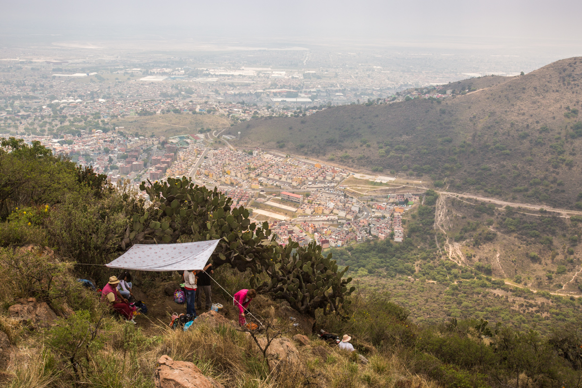
So then it’s not surprising that the name, for residents of the nation’s capital and those following the statistics around the country, stands for violence, for the symptoms of a city incompletely protected. This is to say nothing of persistent (and even growing) problems of kidnappings, rape, and robbery. The name Ecatepec, though, merely refers to a rounded hilltop that looms over the municipality’s historic core. Named in a mix of Spanish and Nahuatl, the language of the Aztec empire, the Cerro de Ehecátl has been dedicated to a god of wind—one that still graces the Ecatepec station of the city’s Metro as its logo—since the Mexica people of Tenochtitlán come to dominate this land in the 15th century. Beginning in 1915, local Catholics have climbed the hill to raise a cross at its summit and offer a prayer.
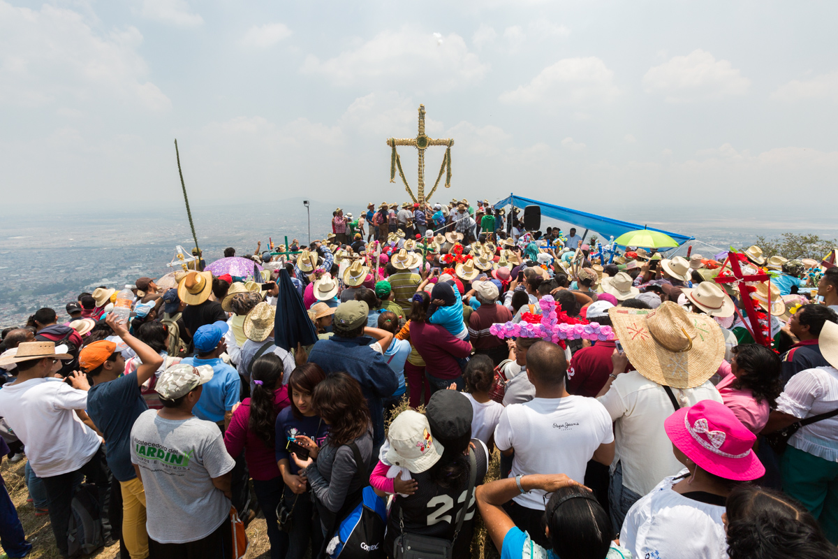
For the hundredth time, in 2015, members of the community held a pilgrimage from San Cristobal to the top of the hill. There, overlooking the sprawling reaches of Ecatepec, buildings fading into a perennial smog that hangs over the city, obscuring its horizon, a priest led the group in a prayer for an end to violence, insecurity, and fear. It was a prayer for all of Ecatepec, from the poorest residents in self-built homes on the barren lakebed to the middle-class residents of gated condominiums. A cross was raised, a parallel ceremony to honor the Aztec god completed, and people began to drink and picnic with a view of the massive, dry bed of Lake Texcoco beyond.
Catholic evangelizers arrived from Mexico City shortly after its conquest in 1521. At that time, the interconnected lakes of the region, including Texcoco, still filled the valley—much of present-day Ecatepec was still underwater, but San Cristobal, in the foothills of the small Sierra de Guadalupe range (of which the namesake hill is a part) was not. It became a small settlement about a day’s journey outside of the former Tenochtitlán along the road to Veracruz; a modest palace for the Viceroy, the colonial head of New Spain, anchored San Cristobal. During the fight to remove that Spanish rule revolutionary leader José María Morelos was executed there; the today, both the city (technically Ecatepec de Morelos) and that palace bear his name. In 1815, he marched to his death in a place remote enough that it was thought the event would not spur a riot; by 1877, the first railroad in the nation offered a stop there.
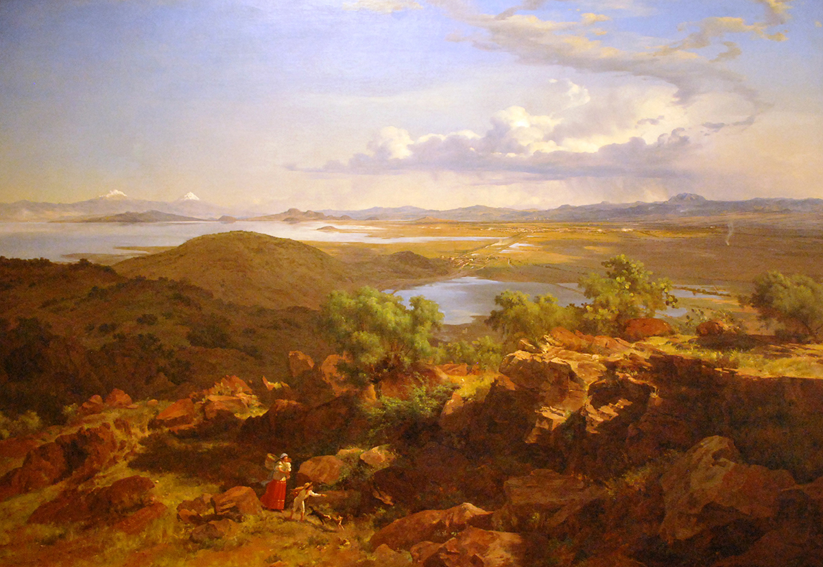
That first railroad preceded him, but the turn of the century is most understood as a time of industrial improvement, in both the capital and (to a lesser extent) the nation under the dictatorial Porfirio Diaz. An 1875 painting by the Mexico State-born painter José María Velasco Gómez, done from a perspective from the Sierra Guadalupe, shows much of the valley, with Mexico City within. It fits well with the descriptions of the city around the turn of the century, a “salubrious place with fresh alpine air and good vibes overall.” The snowcapped volcanoes rise to the east of the city, behind a large, extant Lake Texcoco, and the nation’s capital sits in a wide plain, clearly separate even from La Villa de Guadalupe in the foreground, today an integral part of inner DF. Its a city perched on the edge of accelerating growth, of a sort likely unimaginable at that moment. Velasco never painted Ecatepec—and contemporary railroad maps rendered it as a dot well outside of the capital.
Indeed, Ecatepec figured little into the city of either the region or the country for nearly a century after Velasco’s view from the Sierra Guadalupe. When Díaz was toppled in the tumultuous Mexican Revolution, which lasted from roughly 1910 until 1920, the valley was made up of town centers and agricultural land; nearly 70% of the nation still worked in agriculture. In one of these towns, San Cristobal, on May 3, 1915, a group of Catholics marched to the top of a hill overlooking the city and planted a cross.
Shortly after revolution ended, the Partido Revolucionario Institucional—or PRI—took control of the national government and with it, the capital. The party would remain in power of both until the end of the 20th century. The PRI, through aggressive nationalization of Mexico’s industries and redistribution of agricultural lands, gave rise to the so-called Mexican Miracle, a boom in industrialization that peaked after the second World War. The result was a hugely densified Mexico City—a place of crowded tenements and, for the unlucky, a crushing urban poverty like that chronicled in Oscar Lewis’ classic sociological text, the Children of Sanchez.
In 1945, fearing just this sort of out of control growth, the government of DF under mayor Urchurtu created tax benefits for industries based outside of the Federal District. The state of Mexico was included, and so areas to the north of the city, chiefly Ecatepec, Naucalpan, and Cuautitlán saw explosions in manufacturing. By 1970, 58% of Ecatepec’s residents worked in factories. Herbalife, La Costeña, Jumex, Kimberly-Clark. While the city had been limited, as most had, by the reach of streetcar lines in the first half of the twentieth century, the proliferation of buses eliminated all semblance of order in the growth. Ecatepec’s zones closest to the city, especially those along the road to the northeast to nearby Pachuca, began to burst.
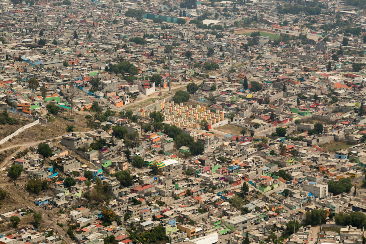
In 1970, Ecatepec held around 200,000 residents; twenty years later, in 1990, the population had grown by one million. In part, this can be chalked up to a much higher birthrate at that time in, and in the growth of social housing—the national organization for which, INFONAVIT, was founded in 1972. Further, lake Texcoco was still in the midst of its long process of desiccation, and much of Ecatepec was still marshland. But the growth on all of the city’s edges at that time was largely informal, the result of a formal market wholly unequipped to deal with the massive in-migration. As one researcher in the mid 1970s described, the places where those of bajos recursos settled were available only because they were "practically un-urbanizable."
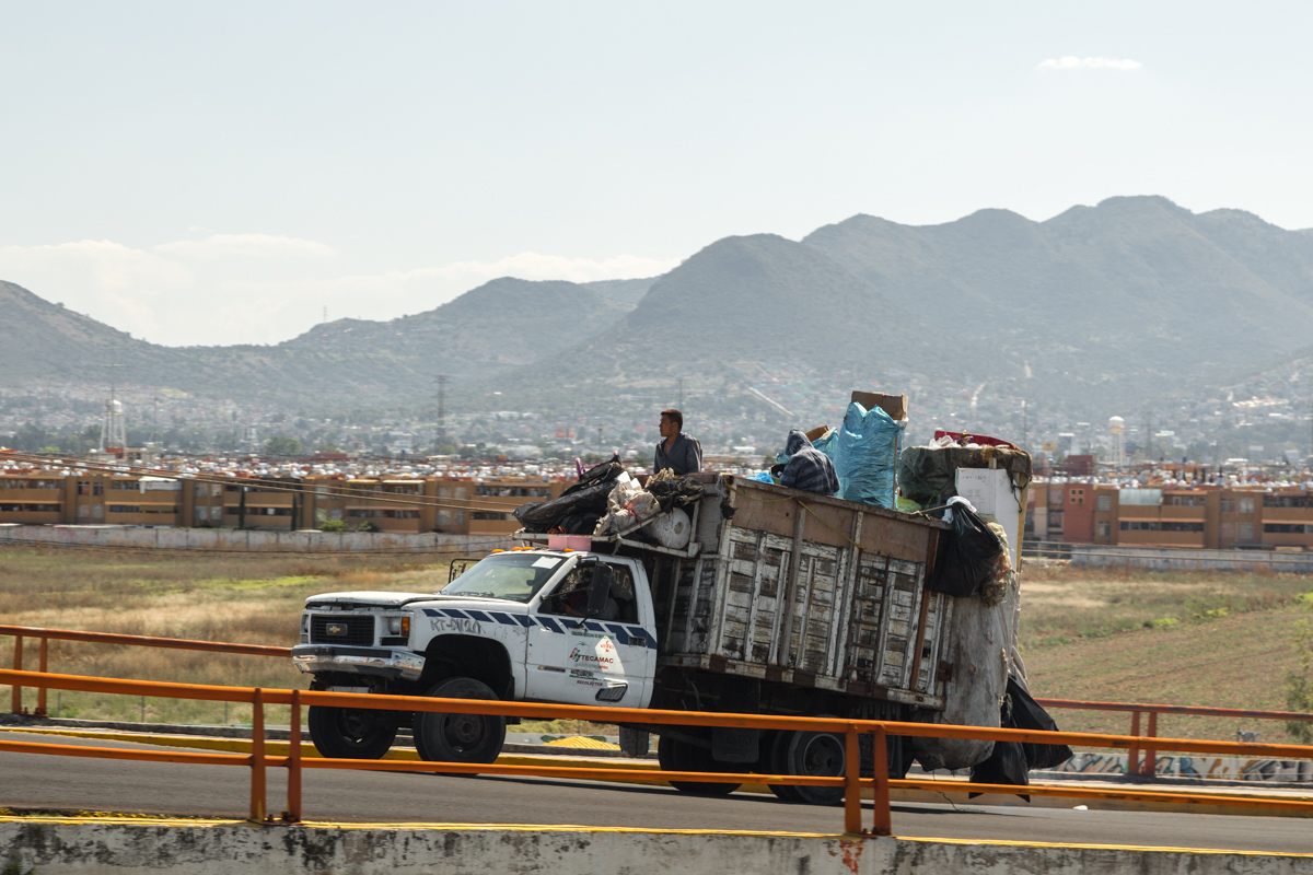
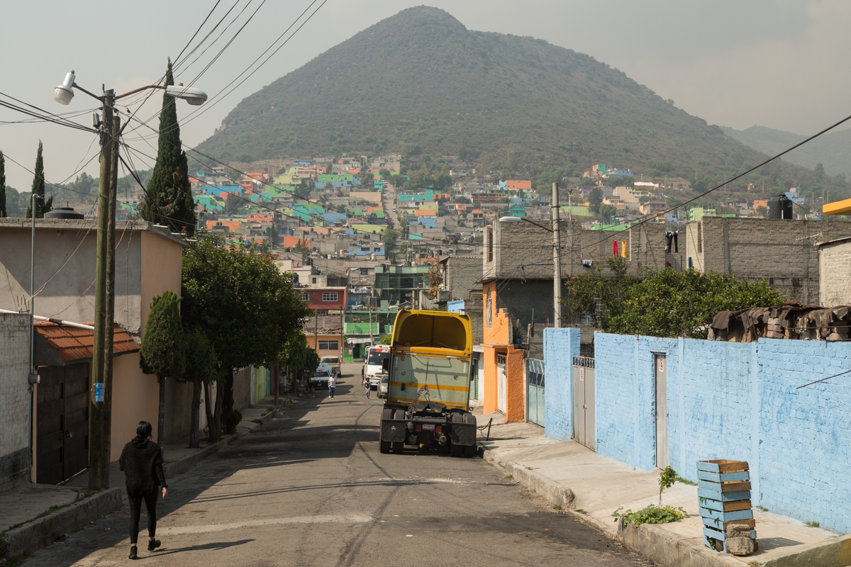
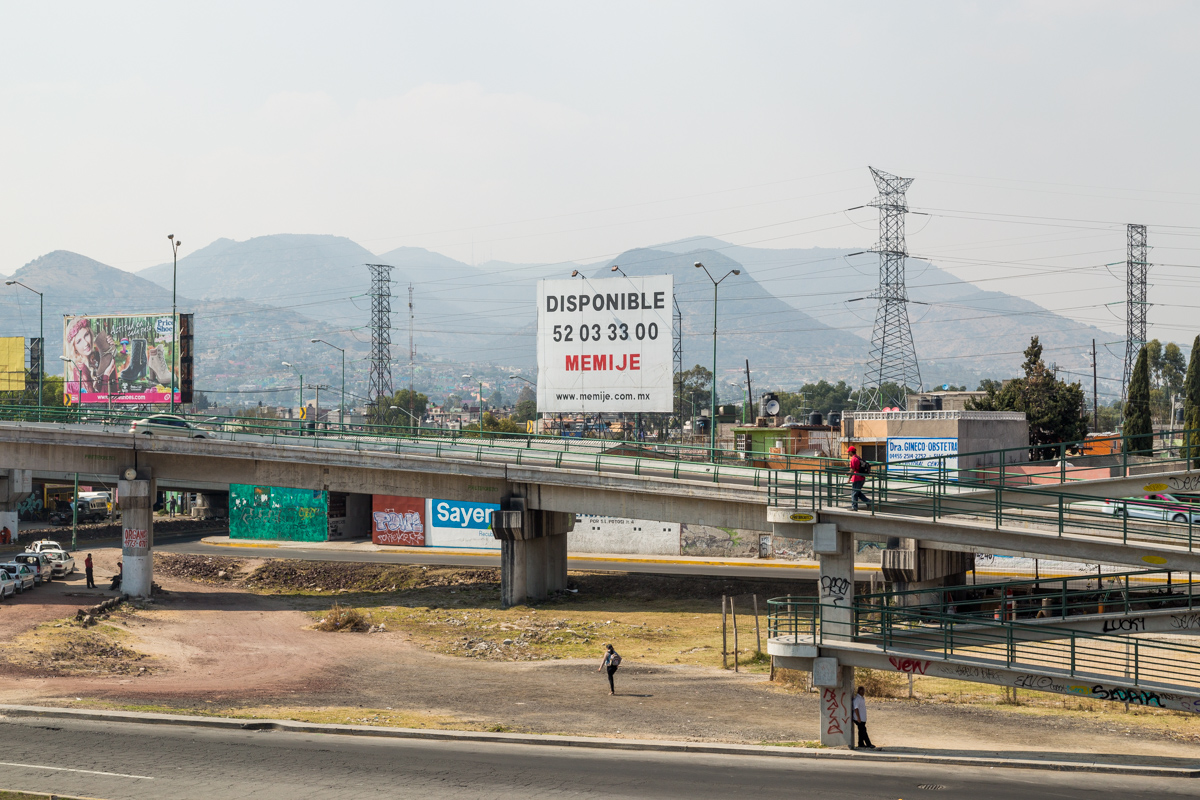
Today, an Ecatepec of 1.6 million residents underlines the ‘practically.’ The view atop the Cerro is that of a new face of Mexico City, emerging from the haze. From the same hills where Velasco captured a lacustrine valley—what Alexander von Humboldt famously called a “city of palaces”—an observer can look out to the north and east and see Ecatepec spreading outward. Lake Texcoco is nearly a memory, and the lakebed even today is subject to encroachment by paracaídistas, or parachuters, as squatters are known. An elevated metro line carries thousands of workers from Ecatepec into DF each day. A sea of cinderblock homes that laps up against the hills and spills outward onto agricultural lands to the north, and even up the side of the Cerro de Ehecatl itself. These blankets of informal housing are punctuated by INFONAVIT-supported developments, visible in large part due to their uniformity. In the distance there is a mall surrounded by empty parking spaces.
Rolando Sanchez Jimenez, a native of Ecatepec in his thirties, lives not far from the shopping center, which anchors the best known INFONAVIT development in the area: Las Américas. The development sits adjacent to the dry lakebed, and on the site of a former factory that produced salt from its leavings. Few traces of the business remain, replaced wholesale with thousands and thousands of largely identical homes. Rolando’s house (which he shares with his wife) is, like the others, organized into a gated unit of perhaps twenty homes. Access to this condominio is controlled by round-the-clock private security and a locked gate; though he describes his daily life as perfectly safe, Rolando tends not to leave the unit at night. Though Las Américas is particularly large development, and distinctly middle class for a part of greater Mexico City that is still struggling, it is nonetheless typical of the millions of homes that have been recently constructed around Mexico City’s edges and, indeed, around the country.
Infonavit, or the National Institute for Worker’s Housing, is not unlike the Federal Housing Administration in the United States—it has a huge impact on the way in which (and therefore cities) are built nationwide, but it does not involve itself with building directly. The organization, broadly speaking, is . From twenty years after its foundation in 1972, Infonavit operated as a builder itself, producing large and often architecturally ambitious projects throughout the capital. But since a reform in 1992, the government exists only a financier, subsidizing mortgages for the roughly 50% of Mexican workers who are employed in the formal sector. Only for the purchase of homes that meet a set of minimum standards, which are, for the most part, built by large consortia. While Infonavit, from its foundation in 1972 until 1992, when it was...

Jimenez used to work in Las Brisas, which si just on the other side of a small wall from Las Americas, though the division is rather profound. An area of informal growth, ....